Background
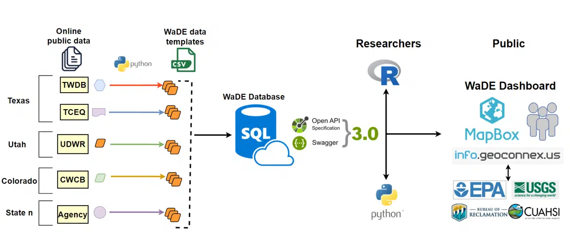
The WaDE data dictionary is a product of a 10-year effort among the western 18 states for an agreed-upon common metadata schema implemented in a centralized data system that is used for sharing water rights and water use data to enable regional analysis that inform policy and planning decisions. The WaDE team import states’ data into a relational database which is exposed to the public through an Application Programming Interface (API). The team is also working with a contractor to build a front end dashboard that will allow decision makers and the public to easily access and analyze water data for the west. WaDE supports the following four fundamental distinct types of water data shared by the member states.
- Water allocations (e.g., water rights and permitting data) which includes Points of Diversions (POD) and Places of Use (POU),
- Regulatory and institutional rules at play within states/basins that regulate water use in a specific area.
- Aggregated water budget estimates such as water supply, withdrawal, consumptive use, return flows, and transfers for reporting areas (i.e., geospatial delineations used by the states such as counties, HUCs, and custom delineations) over time as time series.
- Site-specific time series data for (a) reservoir levels and gages flow and (b) water use data reported at POUs and/or PODs for water supply, withdrawal, consumptive use, return flows.
Site-Specific water use the time-series data dictionary
The U.S. Geological Survey (USGS) Water Availability and Use Science Program is recommending WaDE’s data dictionary in the Data Transfer Guidance for the states who get funding from the Water Use Data and Research (WUDR). We provide the information below to help state agencies understand WaDE’s data dictionary and how to use it in their data sharing with us and USGS.
What metadata does the dictionary include?
This schematic summarizes the key metadata that is required in WaDE for site-specific time-series water use data. The data dictionary is available in this Excel file Data_Dictionary_site_specific_water_data_dictionary_WaDE_08_2021 A template that shows the structure that can be readily used to share data using the dictionary is available for download in this Excel file Template_Site_specific_water_data_dictionary_WaDE_08_2021 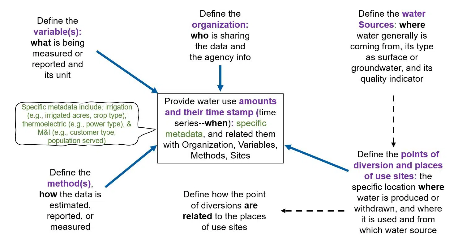
How can a state agency use this data dictionary to share their data with WaDE and USGS?
The dictionary lists the required and optional metadata that is needed to interpret water use data and use it for regional analysis. State agencies have the freedom in implementing the dictionary in any way that fits their existing data-sharing systems. Sharing water use data can be as simple as putting it in a Google Sheet file and making it public. States can also use their own custom data-sharing systems. Or they can leverage off-the-shelf solutions such as ESRI ArcGIS Open Data (Oklahoma), Socrata (e.g., Colorado), CKAN (e.g., New Mexico). Once the state agency publishes their data according to this data dictionary, both WaDE and USGS teams will be able to easily import the data into their centralized data systems. 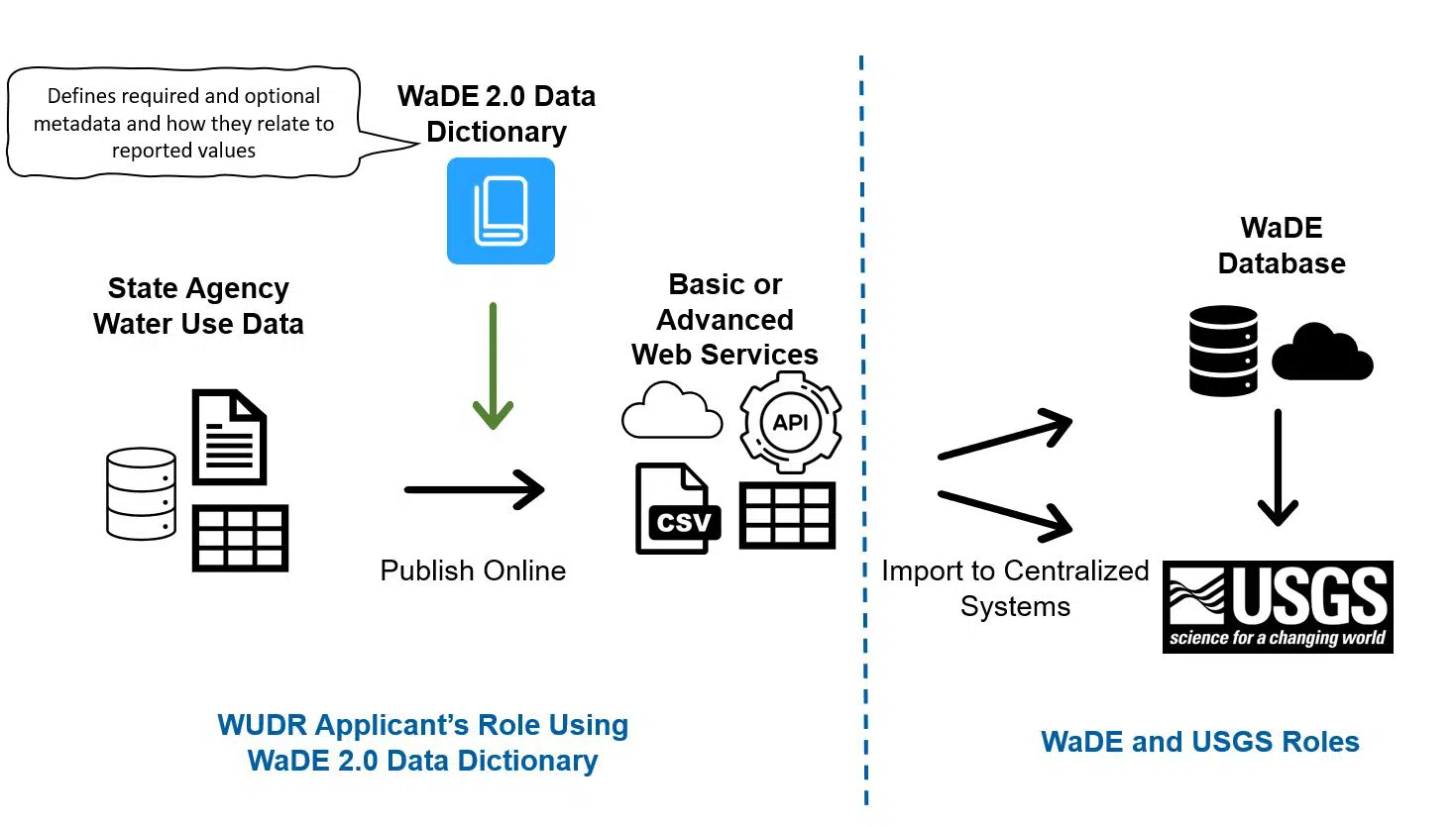
Advanced Users
For those who are advanced in database schemas, you can view WaDE’s site-specific data schema here https://schema.westernstateswater.org/diagrams/2_SiteSpecificAmounts.html
0 Comments