The Western States Water Data Access and Analysis Tool (WestDAAT) Frequently Asked Questions (FAQ)
Note: this page is being reviewed and updated over time.
Who is the Western States Water Council (WSWC) / What is its mission?
The Western States Water Council (WSWC) is a government entity comprised of representatives appointed by the governors of eighteen Western states (i.e., Alaska, Arizona, California, Colorado, Idaho, Kansas, Montana, Nebraska, Nevada, New Mexico, North Dakota, Oklahoma, Oregon, South Dakota, Texas, Utah, Washington, and Wyoming). Its mission is to advise Western governors on policies and programs affecting water in the West and ensure that the West has an adequate, secure, and sustainable water supply of suitable quality to meet its diverse economic and environmental needs now and in the future. https://westernstateswater.org/about/
What is the Water Data Exchange (WaDE) Program / What is WaDE’s mission?
With ever-greater demands on the West’s limited water resources, further complicated by a complex overlay of state and federal laws and regulations, cooperative efforts to exchange water data among the WSWC Member States and with federal agencies have become increasingly important. In response to this growing need, the WSWC launched a Water Data Exchange (WaDE) program in 2011. WaDE is scalable and serves as an aggregate data hub that is being integrated with other federal data providers (Figure 1). WaDE consists of (1) a Microsoft SQL Server Database hosted in Azure; (2) a generic data loader from CSV files into the database; (3) Application Programming Interface (API) endpoints; (4) and a front-end browser-based dashboard known as WestDAAT (see below).
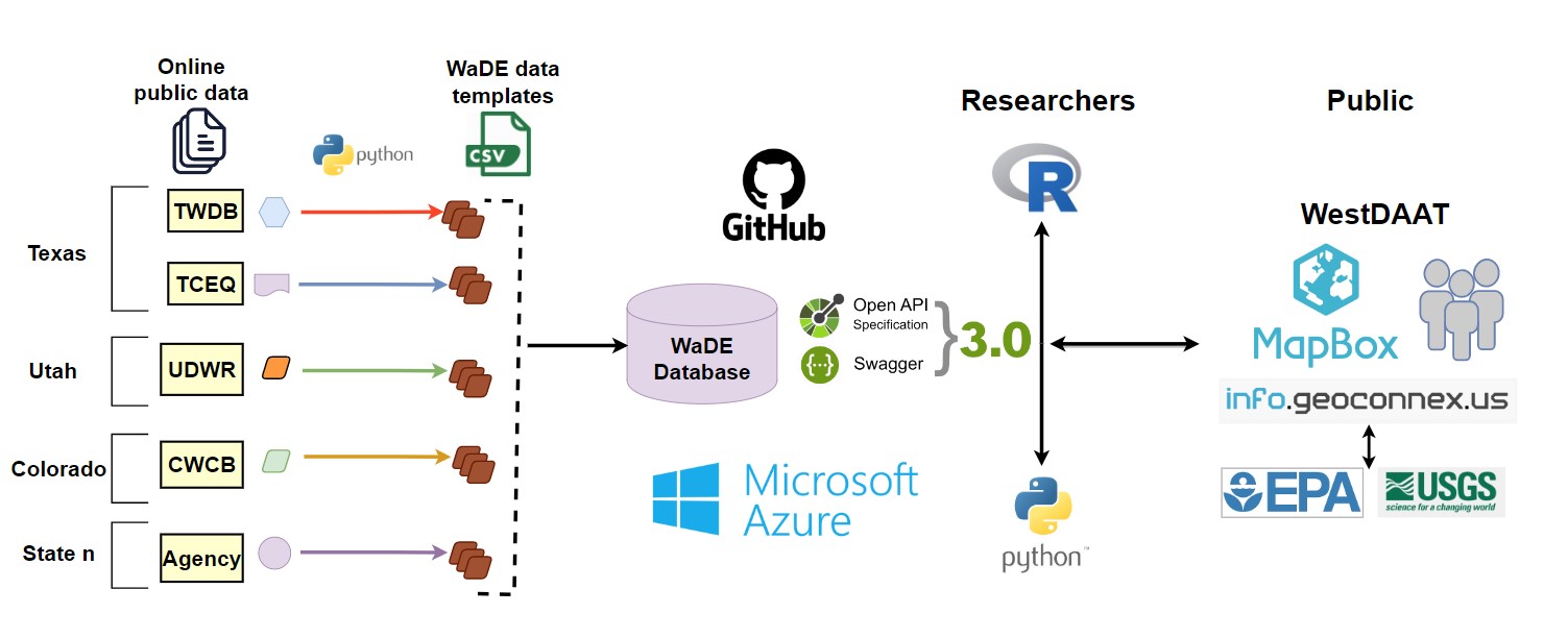
Figure 1: The WaDE Data System architecture. The WaDE team maps and imports Western states’ data into the WaDE database using a common data structure (set of metadata requirements and relationships).
The WaDE Program is committed to assisting the WSWC member states publicly share water data through a common streamlined and standardized service that enables regional analyses to inform water resources planning and policies. All data and system designs are public and accessible under these terms of service.
A History of WaDE, its goals, and intended users are available through this blog post: https://internetofwater.org/blog/wade-celebrating-ten-years-of-western-water-data-sharing/
What is WestDAAT?
The Western States Water Data Access and Analysis Tool (WestDAAT) is an online free and open-access tool that provides streamlined access and analysis to the WaDE Data System water data to support state and regional water planning, management, and decision-making. WestDAAT currently supports access to water rights data across the Western United States but is being further enhanced to support other data types (see below).
When will WaDE / WestDAAT be finished?
The WaDE Program and its accompanying WestDAAT online tool follow an agile development methodology so that new functionality can be continually added to the program in mini-increments. Follow news and updates on the WSWC / WaDE home page: https://westernstateswater.org/wade/
Who is the WaDE and WestDAAT Development Team?
Adel Abdallah is the Program Manager for WaDE and the lead architect of the WaDE 2.0 Data System. Adel oversees WaDE’s development, proposal writing and grant reporting, outreach, and coordination with the Western States Water Council member states and Western States Federal Agency Support Team (WestFAST) agencies, universities, contractors, and collaborators, especially at the Internet of Water Coalition. Adel is a Certified Public Manager and ScrumMaster for agile software development.
Ryan James is the council’s Data Analyst / Hydroinformatics Specialist for the development of the WaDE system. Ryan oversees the extraction, transformation, and loading of state agency data into the WaDE 2.0 architecture. His responsibilities also include generating ML models to categorize state agencies’ water metadata, pipeline development for API data acquisition, and UX / UI design for the improvement of WestDAAT.
What Types of Water Data Does WaDE Provide?
1. Water Rights Allocation and Site Data
In the western U.S., water rights (a.k.a., water allocation) are based on the prior appropriation doctrine “First in time, first in the right.” Each water right has an allocated amount of water (based on a volumetric quantity or a flow rate) with a designated beneficial use (e.g., agriculture) and sometimes multiple uses, which may come from one or many specified water sources. Water right data within WaDE is applied to two distinct site applications: Point of Diversion & Places of Use. Where the point of diversion is the location where water is removed/withdrawn from a natural system (i.e., river, canal, groundwater, etc.), and the place of use is the location where said water is used (i.e., farmstead, municipal city boundary, residential use, etc.).
2. Regulatory Overlays Area Data
There are regulations, compacts, particular management areas, etc., that provide a regulatory framework for water supply and water use across each state in the West. Examples of regulatory overlay involve regulatory/institutional constraints related to statutes, special management areas, regulatory oversight, compacts, or laws that are involved in the regulation of water supply or water use in a given reporting boundary area in any member state.
3. Site-Specific Data
3.1 Reservoirs and Observation Site Time Series Water Data
Reservoir and Observation Site data refer to the historic water flows or volumes by gage stations that States operate year-round or seasonally. This data is separate from streamflow information gathered through federal agencies such as USGS or the U.S. Bureau of Reclamation. Knowing river and reservoir status can help with long-term planning and flood forecasting modeling. Two relative measurements often used are discharge and gage height. Discharge is the rate at which a volume of water passes by a particular location. Gage height is a measurement of the distance between the water’s surface above the stream gage’s datum reference point (i.e., a unique reference point used to accommodate for changes in a stream channel over time). Reservoirs and Observation Site Water Recordings demo: https://waterdataexchangewswc.shinyapps.io/SiteSpecificReservoirAndObservationSiteDemo/
3.2. Site-Specific Public Supply Time Series Water Use Data
Public Supply Water Use refers to the reported deliveries to urban water service areas, known as the place of use (i.e., farmstead, municipal city boundary, residential use, etc.), along with the water source intake locations, known as point of diversion (i.e., river, canal, groundwater, etc.). Put another way, water is withdrawn from site-specific locations and then applied (i.e., depleted) at a different location. Site-Specific Public Supply Water use demo: https://waterdataexchangewswc.shinyapps.io/AggregatedBudgetWaterUseDemo/
4. Aggregated Area Budget Time Series Water Use Data
Aggregated Water Budget Data is modeled and observed data that summarize inflows and outflows into the following five distinct components (i.e., categories) within a geospatial boundary (i.e., area) such as county or watershed: available supply, demand, withdrawal, delivered water, and consumptive use. Consumptive use is an irrecoverable loss from water diverted or withdrawn and not returned to the hydrologic system. Consumptive use is often associated with irrigated agriculture, where water is lost via plant growth through evapotranspiration. Consumptive use for agriculture is often modeled using remote sensing and remains unavailable across most States. States may have consumptive use data that is not publicly available either due to incompleteness, inaccuracy concerns, or sensitivity related to interstate compact administration. Aggregated Area Water Budget time series demo: https://waterdataexchangewswc.shinyapps.io/SiteSpecificPublicSupplyWaterDemo/
Where does WaDE get the data from?
WaDE gets data from state agencies as part of the existing WSWC state members and partners. Data comes in a variety of formats, such as simple hard copy files (i.e., csv, xlsx), to publicly available relational water data databases, to developed application programming interfaces (API) for streaming data. Data is downloaded from these sources and processed by the WaDE staff to fit into the WaDE 2.0 architecture.
Is WaDE data accessible through an Application Programming Interface (API)?
Yes, WaDE public API documentation is available here api.westernstateswater.org
How often is WaDE’s water rights data updated?
Data in WaDE is only updated when the WaDE staff is made aware of any updates to the existing source data provided by the state organizations through the existing WSWC state members and partners. WaDE does not automatically check the status of updates, and the WaDE staff depends on the providing organizations to let them know an update has been made available. The date of the last update of the provided source data being processed by the WaDE staff is tracked as part of the WaDE 2.0 architecture. Current water right data used by WaDE and the date it was processed can be seen here: https://westernstateswater.org/wade/water-rights-data/
Are there tribal water rights included for any of the states? Are they identified separately?
Tribal rights are not necessarily individual rights, may not have a defined point of diversion or place of use, and in many cases, they are not yet quantified. However, defined tribal rights that are recognized in the States databases are shared in WestDAAT and may appear under the Oner Classification value “Native American.”
Are there Federal Reserve water rights, such as the military?
We do have their recognition, or they have state-granted rights, or the Forest Service or Bureau of Land Management (BLM), we have been able to identify some of those.
How does WaDE represent the site, either place of use or point of diversion coordinates, and snap it to NHD network if the longitude and latitude coordinates are not known of the site?
When the exact location is unknown or digitized, many states share the quarter-quarter boundary where the site exists within it. For WaDE regional purposes, we used the entire quarter-quarter polygon for the place of use and the centroid of it for the point of diversion.
A question about the source code and license (Can states use a dashboard and customize it for their individual needs?): GitHub https://github.com/WSWCWaterDataExchange/WestDAAT
For WestDAAT, how are you symbolizing the right water points that possess multiple beneficial uses?
Information on multiple beneficial uses per water right is tracked and stored as part of the WaDE preprocessing and data uploading. This information is also delivered upon data download as part of that query. However, due to structural limitations, WestDAAT does not support the visualization of water rights with multiple beneficial uses. WestDAAT beneficial use categories viewed on the online tool are based on what is considered to be the primary beneficial use (a.k.a., PrimaryUseCategory), which was assigned by utilizing a keyword search algorithm using the state-provided beneficial use terms on a hierarchical system that provided the least amount of errors.
What are the Terms of Service?
Please visit this webpage https://westernstateswater.org/wade/westdaat-terms-of-service/