Summary
The Western States Water Data Access and Analysis Tool (WestDAAT) was rolled out of production in September 2022 and was publicly released On April 25, 2023. The WSWC kicked off the public release via a webinar hosted by the Internet of Water Coalition, with 175 participants attending. In August, the IoW Coalition published a blog post, “Unveiling WestDAAT,” highlighting WestDAAT’s capabilities. From September 2022 through December 2023, 1,761 unique users have visited WestDAAT across the US and 48 international visitors. Most WestDAAT visitors are from the Western US and around the Washington District of Colombia (Figure 1). The 48 international visitors from the following countries: Brazil, Canada, China, Costa Rica, Germany, Hong Kong, Indonesia, Ireland, Kenya, Mexico, Netherlands, Portugal, Puerto Rico, Saudi Arabia, Slovenia, South Korea, Spain, United Kingdom, United States, and Venezuela. Of note, Canada has the highest of visitors at 14.
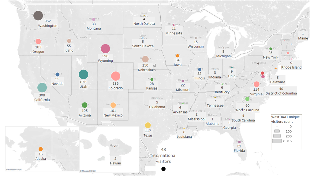
Figure 1: WestDAAT unique visitors across the US from September 2022 through December 2023. Total 1,761 unique visitors
The public release drew more attention to WestDAAT and spiked unique returning visitor numbers who signed up to download available data. WestDAAT offers free access, analysis, and visualization, but to download data, users are required to create a free WestDAAT account. Returning visitors indicate more interest in WestDAAT than a one-time visit (Figure 2). Of the 1,761 visitors since its release, 423 are active and returning to WestDAAT. Among those returning visitors, 47 users created accounts that allowed them to download data. These account users came from Arizona, California, Illinois, Colorado, Maryland, Massachusetts, North Dakota, Nebraska, New Mexico, New York, North Carolina, North Dakota, Oregon, Pennsylvania, Texas, Virginia, Washington, and West Virginia. They belong to these groups: City, Consulting, Federal, Non-profit organizations, State, and University.
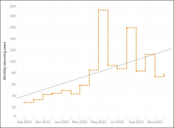
WestDAAT is gaining new users each month (Figure 3) and maintaining monthly returning visitors (Figure 4).
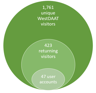
Figure 2: WestDAAT unique daily returning visitors from September 2022 through December 2023.
 Figure 3: Growing monthly WestDAAT new unique users reaching 1,761 from September 1, 2022. through December 31, 2023. The biggest jump was during the public release in May 2023.
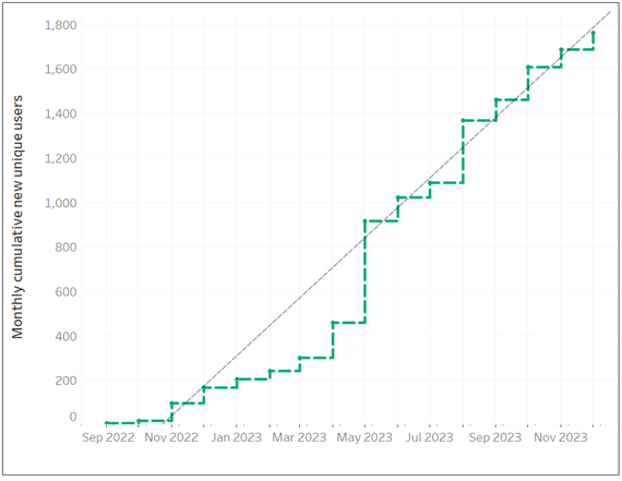
 Figure 4: WestDAAT unique monthly visitors and monthly returning visitors from September 2022 through December 2023. Overall, 423 unique users returned to WestDAAT more than once. While WestDAAT returning visits have been trending up since its launch, the last few months hovered over 80-100 returning visitors per month.
Key Users
1. User: Bureau of Reclamation
Project: Water Rights Information Management System (WRIMS)
Goal: Reclamation is developing WRIMS as a “centralized repository of information on Reclamation’s interests in water rights to ensure they are inventoried and protected to avoid litigation processes on authorized Reclamation projects. Developing this water rights information management system will streamline data collection and maintenance of Reclamation’s water rights, improve data quality and data integrity, and ensure consistency. Improved data management, integration, and consistency in business practices will result in significant resource savings with regards to funding, time, and staff.”
How is WestDAAT being used? Reclamation staff is directly querying water rights data from WestDAAT that the Western States recognizes for Reclamation as an owner. In addition, WSWC is collaborating with Reclamation to classify water rights that receive water from Reclamation projects such as districts or canal companies. This effort is important because Reclamation “provides 1 out of 5 (or 140,000) Western farmers with irrigation water for 10 million farmland acres that produce 60 percent of the nation’s vegetables and one-quarter of its fresh fruit and nut crops.”
2. Kat Hoenkeat at the Southeast Aquatic Resources Partnership
Project: Aquatic Barrier Prioritization Tool: Southeast and Intermountain regions.
Goal: To build a community of practice among resource managers and enable them to identify high-priority aquatic connectivity restoration projects. Regularly updating barriers in this inventory allows it to reflect better the degree of aquatic habitat fragmentation from aquatic barriers across political boundaries at a national scale.
How is WestDAAT being used? The team uses WestDAAT’s data to identify infrastructure and small dams affecting stream connectivity. “WestDAAT has been extremely useful for us. It is currently used in our national aquatic barrier inventory and prioritization tool at https://aquaticbarriers.org when Points of Diversion (PODs) have a structure present. We use the data to find undocumented diversion structures that block habitat to aquatic species by manually reviewing those that map to streams. Sometimes we find hundreds of additional dams we previously did not have in our inventory. In addition, we are working on aligning WestDAAT data to existing structures to identify the water rights and beneficial use information so that it can be used as filters in our prioritization tool.”
3. User: Dr. Landon Marston Research Group at Virginia Tech.
Project: Toward resilient and adaptive community-driven management of groundwater-dependent agricultural systems.
Goal: model agriculture water use curtailment due to drought and the impact on national and global food supplies.
How is WestDAAT being used? The project will pair land use ownership with WestDAAT water rights and infrastructure to link water rights to land. Dr. Marston Group downloaded a copy of WestDAAT’s water rights data.
4. User: Dr. Benjamin Ruddell Research Group at Northern Arizona University
Project: Mesoscale Data Fusion to Map and Model the U.S. Food, Energy, and Water (FEW) System.
Goal: Identify adaptive options for farmers in the Colorado River Basin.
How is WestDAAT being used? The team is using WestDAAT to map what adaptive options are available in the region based on existing water rights and any unallocated water.
5. User: Economic Research Service at the United States Department of Agriculture (USDA)
Goal: develop models on the economic impacts of reduced snowpack on agriculture across the Western U.S., especially the Colorado River Basin.
How is WestDAAT being used? The team is using WestDAAT to examine drought impacts on junior vs. senior water rights.
6. User: The Program on Coupled Human and Earth Systems (PCHES), Pennsylvania State University
Goal: The team focuses on driving innovations in the modeling and analyzing multisector, multiscale land, energy, water, and infrastructure systems to advance understanding of complex risk and response behaviors.
How is WestDAAT being used? The team uses WestDAAT data to model multi-sector dynamics of intersectoral water allocation changes through water markets.
7. User: Certain Measures and Wright-Ingraham Institute
Goal: develop an educational data visualization tool relating to water rights for the Colorado River.
How is WestDAAT being used? The team uses WestDAAT data as input to their model that aggregates surface water rights in the Colorado River Basin.
8. User: Vibrant Planet
Project: The team developed a Land Tender online to assess wildfire risks and model landscape restoration.
How is WestDAAT being used? The team is considering using WestDAAT data, especially points of diversion, as a water infrastructure layer in their Land Tender tool to inform the prioritization of landscape restoration measures that protect from wildfires.
Update: March 1, 2024