What is WaDE and What Type of Data is Stored?
The Water Data Exchange Program (WaDE) is a centralized and cloud-based data system committed to assisting the eighteen Western States Water Council (WSWC) member states in making their water rights, water supply, water use, and administrative and regulatory overlay data more findable, accessible, interoperable, and reusable (FAIR) through a streamlined and standardized platform. WaDE does not replace existing state systems, but does provide a singular and centralized service for state water data, which enables a more accessible regional analyses to better inform water resources planning and policies that cross state boundaries. Data stored in WaDE is broken down into four main data categories / types: 1) water right, 2) water supply, 3) water use, 4) overlay. See below for further details and analysis on the progress of each defined data type.
How to Access WaDE Raw and Processed Data Outside of WestDAAT?
Each state is unique in how they measure, determine vocabulary, and store water related data. The WaDE system enables streamlined access to all the WSWC member states’ water data at a high-level granularity. WaDE does use its own metadata and database structure schema to store water information [see wade-design-docs] with consideration to conserve the state sourced data schema as best as possible. New water data is continually being added over time and may gradually change over time once updated or available (e.g., existing water rights may change ownership or legal status). Data in WaDE is updated around twice a year as there is no current auto-update system implemented.
WaDE OGC API Retrieval Service: API retrieval services, does require key to access (reach out to WaDE staff for available key) [see API-Docs].
GitHub Data Documentation: A breakdown of where the water data came from and how it was processed to fit into the WaDE environment. Structured by state, agency (if distinct), and data type. [see wade-mappingstatedatatowade2.0-github].
Google Drive Raw and Processed File Storage: Google Drive storage of the raw data provided by the state agency (i.e., RawInputData) and the processed data fit into the WaDE environment (i.e., ProcessedInputData). Structured by state, agency (if distinct), and data type. [see google-drive-file-storage].
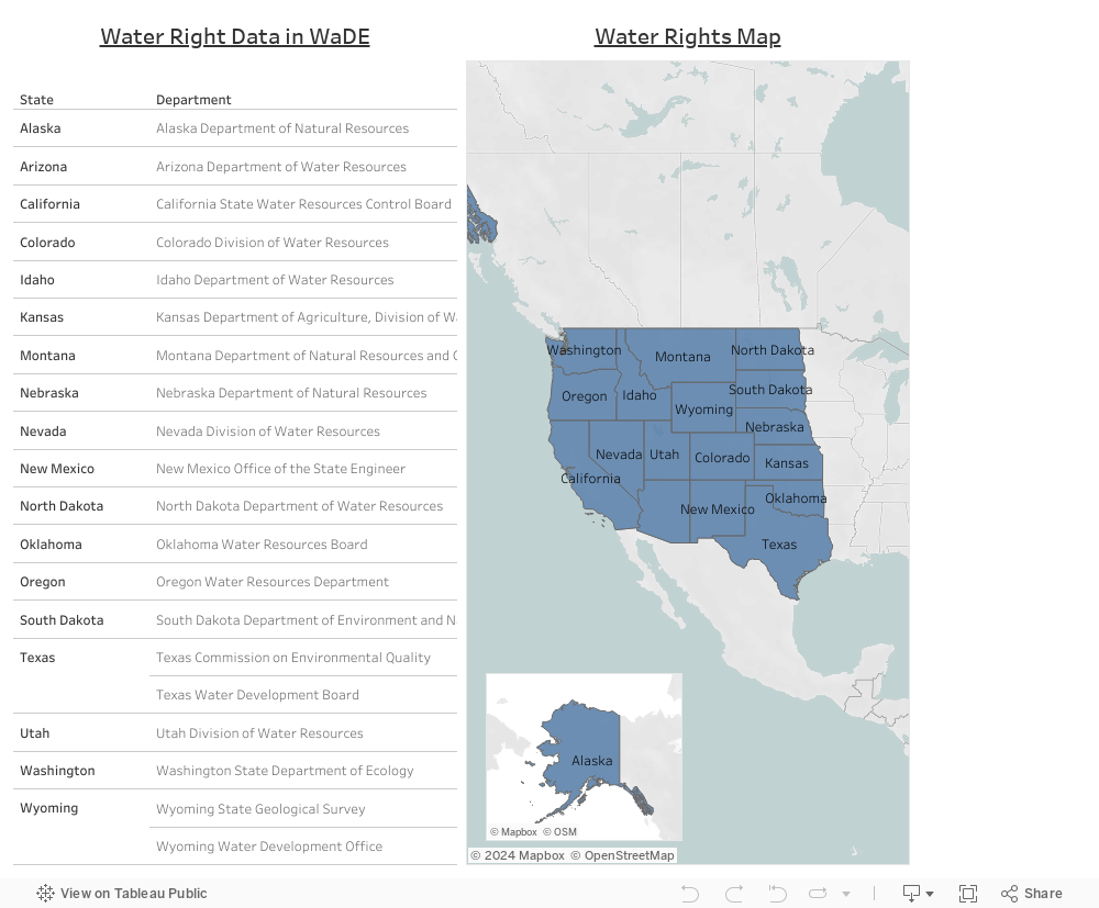
What is Water Right Data?
State water rights in western states are predominantly administered under the Doctrine of Prior Appropriation, generally governed by priority date, “first in time, first in right,” and limited to reasonable beneficial use. Waste is prohibited, as is injury to prior senior water rights, and water not “used” is subject to forfeiture, “use it or lose it.” The latter was designed to limit speculation, ensure applicants had the means to develop a water right, and maximize the economic benefit to the state. Modern adjustments have been made to recognize instream flows and other environmental or recreational non-consumptive uses, as well as allow for water banking, leasing, and other water marketing mechanisms to be applied temporarily. All water use must be reasonable and beneficial regardless of the underlying water rights. No one has a right to unreasonably water use. This applies to both consumptive and non-consumptive uses. As it relates to agriculture and irrigation, what is considered reasonable is often defined by local custom, though a statutory “water duty” may exist. In practice, the application tends to be cumbersome, often a process that is largely reactive once someone claims another’s use of water is unreasonable, which may involve judicial or administrative due process. Reasonableness is defined and determined under state water law and may be part of a general adjudication proceeding. Most owners or managers of irrigated lands in the West do not directly measure consumptive use, which is a critical element of water budgeting. Evapotranspiration (ET) includes evaporation and transpiration from crops that consume water, which often serves as a useful but only partial proxy for consumptive use. Measuring and monitoring ET on irrigated lands using satellite-based remote sensing has increased over the past couple of decades. Consumptive use includes ET, canal, reservoir evaporation, and other irrecoverable water losses, such as deep percolation and outflows to the ocean or saline terminal lakes (which may or may not provide other environmental and/or societal benefits). Attributes of state water rights usually include the owner name, point of diversion or withdrawal, place of use, the purpose of beneficial use(s) (e.g., agriculture), a limit on the flow rate or total quantity consumptively used (sometimes including a customary water duty), and a priority date, with a designated beneficial use (e.g., agriculture) and sometimes multiple uses, which may come from one or many specified water sources. The “water right” term in WaDE is broadly applied to include state-granted rights to the use of public waters via public and private appropriations, permits, allocations, allotments, and reservations. Of note, domestic wells may or may not require a state water right though withdrawals may be limited; and groundwater use managed under a correlative rights or proportionate use doctrine, as in some western states, limits landowners to a reasonable share of the total water supply. WaDE supports data access to the following five types of water rights across the Western 18 states. Each type has its unique legal aspects that govern water use…
- Prior appropriation (the vast majority of water rights in WestDAAT)
- Riparian (a fraction of California surface water rights)
- Rule of capture (Texas groundwater)
- Correlative Rights (California groundwater)
- Reasonable Use (Arizona groundwater outside Active Management Areas and Nebraska groundwater)
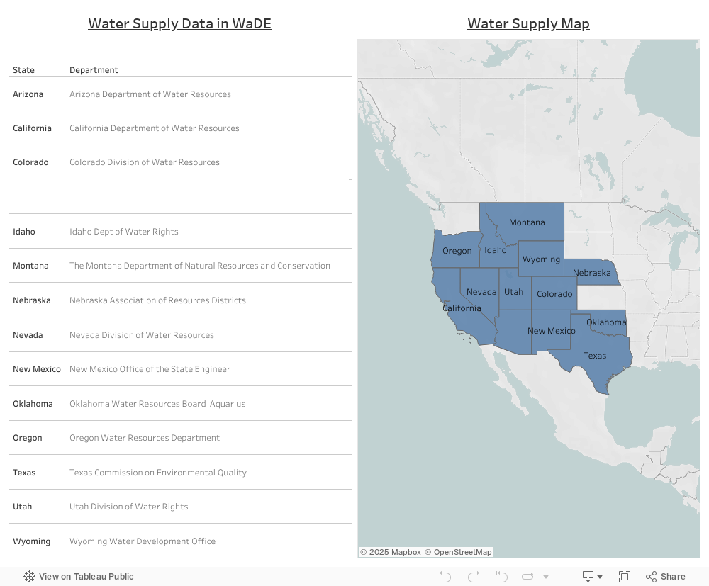
What is Water Supply Data?
Water supply data in WaDE is state agency sourced stand-alone historical measurements and observations made over time on sources or bodies of water to determine the supply and health of those bodies of water. Water supply measurements are not necessary tied to any water right or water use record. Example measurements of water supply data from state agencies include reservoir level and storage volume, stream gage flow and height, groundwater and aquifer depth, etc. Water supply data can either be a singular site-specific record (e.g., stream gage measurements), or an aggregated summation to a larger area (e.g., water budget for hydrologic unit).
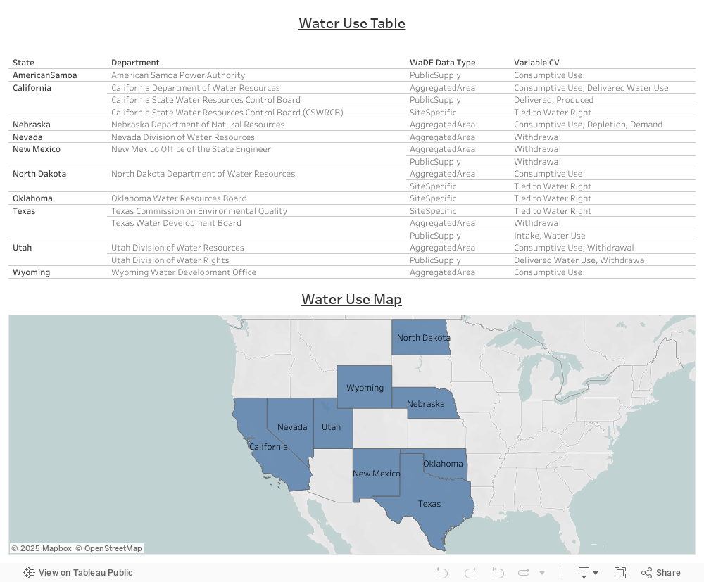
What is Water Use Data?
Water use data in WaDE is state agency sourced historical measurements or estimations of the amount of water that is taken from a source or body of water (similar to water supply) but for a well defined & specific purpose. Data can be considered withdrawal (i.e., water taken from a source and either permanently or temporarily conveyed to a place of use), consumptive (i.e., water taken from source and permanently conveyed to a place of use. Use can be evaporated, transpired, incorporated into products or crops, consumed by humans or livestock, or otherwise not available for immediate use or transfer again), or estimates on the expected demand or measured delivered amount. Water use data can either be a singular site-specific record (e.g., well withdrawals tied to a legal water right), aggregated summation to a larger area (e.g., recorded demand for a county), or site-to-area public supply withdrawals and use (e.g., public and private water suppliers that deliver to users for domestic, commercial, and industrial purposes).
What is Overlay Data?
Overlays are unique geographic areas & regions where specific regulations or rules apply to the state’s water rights, supply, and use. Overlays can also be administrative boundaries of districts or offices with authority over water. Each overlay has a geospatial boundary, name, a type (e.g., regulatory, administrative, hydrologic unit, etc), the water source type (e.g., surface water, groundwater), an oversight agency, and a hyperlink that points to online documentation provided by the oversight agency. For example, water right site data is mapped to overlay information that defines whether it is subject to either a administration or regulation.

WaDE Common Vocabulary (CV) Terms and Definitions
Below are the terms and their definitions used to categorize water related data viewable on WestDAAT. These terms are used as high-level categorical bins for both sorting the state data into easily manageable and recognizable bins, and user-friendly filter terms used on WestDAAT. Listed terms and definitions do not replace existing states’ own terminology with similar vocabulary. Definition of listed WaDE terms have been put together by the WaDE team to the best of knowledge, with respect to the states’ own terms and keeping with the overall goal of WaDE to improve regional analysis without replacing existing state systems. Listed terms and definitions used are subject to change as WaDE involves over time with increased data and further improvements. Definitions for listed terms come from a variety of sources including the U.S. Geological Survey Water Science Glossary,[1] the U.S. Bureau of Reclamation Library Glossary,[2] and the U.S. Department of Justice Legal Term Glossary.[3]
[1] USGS Water Science Glossary: https://www.usgs.gov/water-science-school/science/water-science-glossary
[2] USBR Library Glossary: https://www.usbr.gov/library/glossary/
[3] DOJ Legal Terms Glossary: https://www.justice.gov/usao/justice-101/glossary
