How to Use WestDAAT Filters?
This page explains the usage and terminology behind each WestDAAT controls and filters. WestDAAT is currently separated into three different sections: (1) Basic Functions, (2) Water Right Selection Filters, (3) Time Series Filters, (4) Overlay Filters, and (5) NLDI Filters
(Note: This page has is reviewed and updated over time)
Basic Functions
Basic functions including: reset all filters, map theme toggle, download data, site selection tools, analytics and table popups.

1. Reset All Filters: The Reset All Filters button allows the user to reset all user-selected filters back to their starting default values.
2. Map Theme Toggle: Button that changes the background imagery. Gives the user the option to view the data displayed on a different background map.
3. Download Data: Download water right data, up to 100,000 records. Requires sign in.
4. Site Selection tools: Drawing tools for both water right and time series sites Tools include draw circle polygon, draw square polygon, and a new custom input file select from the user (accepted file types include shape files (shp) and geojson).
5. Analytics & Table Popup: Water right analytic visuals. Includes pie chart, bar chart, ability to group results (e.g., beneficial use, water source type, owner type, allocation type, legal status type, site type), and table information for water right data.
Water Right Selection and Filters
This section contains controls that allow a user to filter down the available sites on the accompanying map based on the following criteria related to water right information: change map color legend, toggle point size), toggle view, state, beneficial use classification, water source type classification, text search box for water right owner name, owner type classification, allocation type, Legal Status, Site Type, river basin selection demo, water right POD or POU toggle, priority date beginning and end date range entry, water right assigned flow minimum and maximum range entry, and water right assigned volume range minimum and maximum range entry.

1. Change Map Color Legend: The drop-down list changes the accompanying map legend, which displays the meaning of the colors and styles used to represent geographic data on the map. Data relates to the following specific to water rights data: (1) beneficial use classification, (2) owner type classification, and (3) water source type classification.
2. Toggle Point Size: Toggle button that changes the POD size on the accompanying map to the following: (1) Default, which makes all points the same & is the standard size; (2) Flow, which sizes POD points based on assigned allocated to the water right; (3) Volume, which sizes PODs points based on assigned allocated volume to the water right.
3. Toggle View: The toggle button changes the view to include: (1) All POD and POU sites; (2) just POD sites; (3) just POU sites.
4. State: A drop-down list of states where available water rights data can be found. States are presented in alphabetical order in abbreviated form.
5. Beneficial Use: A drop-down list of WaDE classified specific use(s) authorized under a water right expressed in terms of the purpose(s) to which the water may be applied. WaDE classified beneficial uses are for sorting and viewing purposes only for WestDAAT and have been approved by the WSWC member states. They are an abridged list of common terminology from the vast array of recognized beneficial uses throughout the Western States. See individual water right landing pages for provided native state terminology.
6. Water Source Type: A drop-down list of WaDE classified water source types applied to water rights. Types mostly include water rights sites divided between surface water, groundwater, and unspecified (site sites that were not able to be classified). WaDE-classified water source types are for sorting and viewing purposes only for WestDAAT and have been approved by the WSWC member states. They are an abridged list of common terminology from the vast array of recognized water source types throughout the Western States.
7. Search Allocation Owner: A single-line text box that accepts the user’s input search strings to perform an exact search on Water right’s owner name information as recognized by the providing state organizations.
8. Owner Classification Type: A drop-down list of WaDE classified owner types applied to water rights. They are an abridged list of common terminology from the vast array of recognized owner types throughout the Western States. Assigned values are determined by utilizing a keyword search algorithm using the state-provided water right owner (e.g., Allocation Owner) information. The keyword search starts with a generic term search but then is overridden with a more term-specific search. Water right records can possess multiple owners and records within WaDE with multiple Allocation Owner entries were given the first term available. Terms not found in the keyword search were given the default value of “In Review”, for further review by the WSWC staff and state agencies. For more information on how owner types are determined, see here.
9. Allocation Type: A drop-down list of WaDE classified type of water right (e.g., Underground Water Claim, Federal Reserved Water Right, etc).
10. Legal Status: A drop-down list of WaDE classified state recognized legal status of the water right (e.g., proven, approved, perfected, adjudicated, etc.)
11. Site Type: A drop-down list of WaDE classified high-level description of the site type recognized by the data provider, specific to water rights (e.g., well, spring, reservoir, river, ditch, etc.).
12. River Basin Areas: A drop-down list of river basins is used to select water right locations within a specific river basin area. Provided list is for demonstration purposes only using those areas that received the most requests during the development of WestDAAT. Plans on either expanding the available list to include additional river basins or plans on expanding the tool itself to encompass a larger variety of area types are in development and will be made available sometime in the future.
13. Availability of Priority Data and Amounts: Toggle button that displays water rights sites & records determined to be exempt from WaDE’s data mapping regulations and rules. Sites and records include those missing information that is key to the WaDE 2.0 system architecture but considered excused as missing information will not be readily available for some time. Missing key information can include one of the following: (1) the lack of provided flow or volume allocation records per water right recognized by the state, or (2) a recognized priority date not provided or ever recorded for the water right.
14. Priority Date: Date range input control that allows a user to select dates that would encompass a water right date record. Can define a custom date range by choosing start and end dates. Values are given in MM/DD/YYYY format.
15. Flow Range (CFS): Flow range input control allows a user to select flow values that would encompass a water right date record. Can define a custom flow range by entering in a minimum, maximum, or both flow value(s). Appropriate values range from 0 and up.
16. Volume Range (AF): Volume range input control that allows a user to select volume values that would encompass a water right date record. Can define a custom volume range by entering in a minimum, maximum, or both volume value(s). Appropriate values range from 0 and up. Might be worth adding a list of all options in each drop-down CV filter either here listed in a table, or a link to a posted page on a WSWC / WaDE documentation page that talks about the CV terminology project(s).
Time Series Selection and Filters
State based historical time series records on water supply and use, alongside the existing water right site information. Each site is classified by the type of time series, the site type, it’s primary beneficial use, the state it is located in, the type of water source type of the record, and a time series date range. Includes WestDAAT site landing pages that show site information and time series information. Users of this data will be able to more easily answer questions like the following: (1) Where are related points of diversion/return and their actual volume or flow values in a hydrologic system? (2) What is the annual time series for a given set of sites with known beneficial use categories, water source types, and/or methodologies? and (3) What responses may be appropriate given real-time changes to reservoir levels, streamgage heights, or longer-term changes such as groundwater levels.

1. Time Series Variable Type: A drop-down list of WaDE classification of measurements of timeseries data (e.g., water supply data, water use data, water use data tied to water rights, etc).
2. Site Type: A drop-down list of WaDE classified high-level description of the site type recognized by the data provider, specific to time series data (e.g., well, spring, reservoir, river, ditch, etc.).
3. Primary Use Category: A drop-down list of WaDE classified specific use(s) expressed in terms of the purpose(s) to which the water may be applied.
4. State: A drop-down list of states where available time series data can be found. States are presented in alphabetical order in abbreviated form.
5. Water Source Type: A drop-down list of WaDE classified water source types applied to time series data. Types mostly include sites divided between surface water, groundwater, and unspecified (site sites that were not able to be classified). WaDE-classified water source types are for sorting and viewing purposes only for WestDAAT and have been approved by the WSWC member states. They are an abridged list of common terminology from the vast array of recognized water source types throughout the Western States.
6. Time Series Date Range: Date range input control that allows a user to select dates that would encompass a time series date record. Can define a custom date range by choosing start and end dates. Values are given in MM/DD/YYYY format.
Overlay Selection and Filters
Geospatial overlay geometries paired with water right site information. Each overlay has a geospatial boundary, name, type of overlay, the water source type it applies to, an oversight agency, and a hyperlink that points to online documentation provided by the oversight agency. In the WaDE database, each overlay is mapped to water rights. Thus, administrative and regulatory overlays are geospatial metadata related to water rights that provide context to surface and groundwater water rights and water use across the West. Each overlay has a landing page with its metadata and a hyperlink to the oversight agency. Users of this overlay information will be able to answer questions like the following: (1) What are the administrative or regulatory agencies or districts with authority over groundwater or surface water across the West? (2) What local or regional regulations exist in an area of interest? and (3) What water rights or water uses could be impacted by an administrative or regulatory decision?

1. Overlay Type: A drop-down list of WaDE classified overlay types (e.g., administrative, regulatory, etc).
2. State: A drop-down list of states where available overlays data can be found. States are presented in alphabetical order in abbreviated form.
3. Water Source Type: A drop-down list of WaDE classified water source types applied to overlay data. Types mostly include sites divided between surface water, groundwater, and unspecified (site sites that were not able to be classified). WaDE-classified water source types are for sorting and viewing purposes only for WestDAAT and have been approved by the WSWC member states. They are an abridged list of common terminology from the vast array of recognized water source types throughout the Western States.
NLDI Filter
This section contains controls that allow a user to utilize the Hydro Network-Linked Index (NLDI) and Geoconnex Framework tool. This tool is a system that can index spatial and river network-linked data and navigate the river network to allow the discovery of indexed information. NLDI puts a restful application programming interface (API) in front of the National Hydrography dataset. For further information, see here: https://waterdata.usgs.gov/blog/nldi-intro/ This tool has the following applications for WaDE: (1) drag and drop pin tool, (2) text entry box for latitude values, (3) text entry box for longitude values, (4) toggle button to indicate the direction of the query of site data, (5) toggle button to receive site information for other federal agencies as part of the Geoconnex Framework.
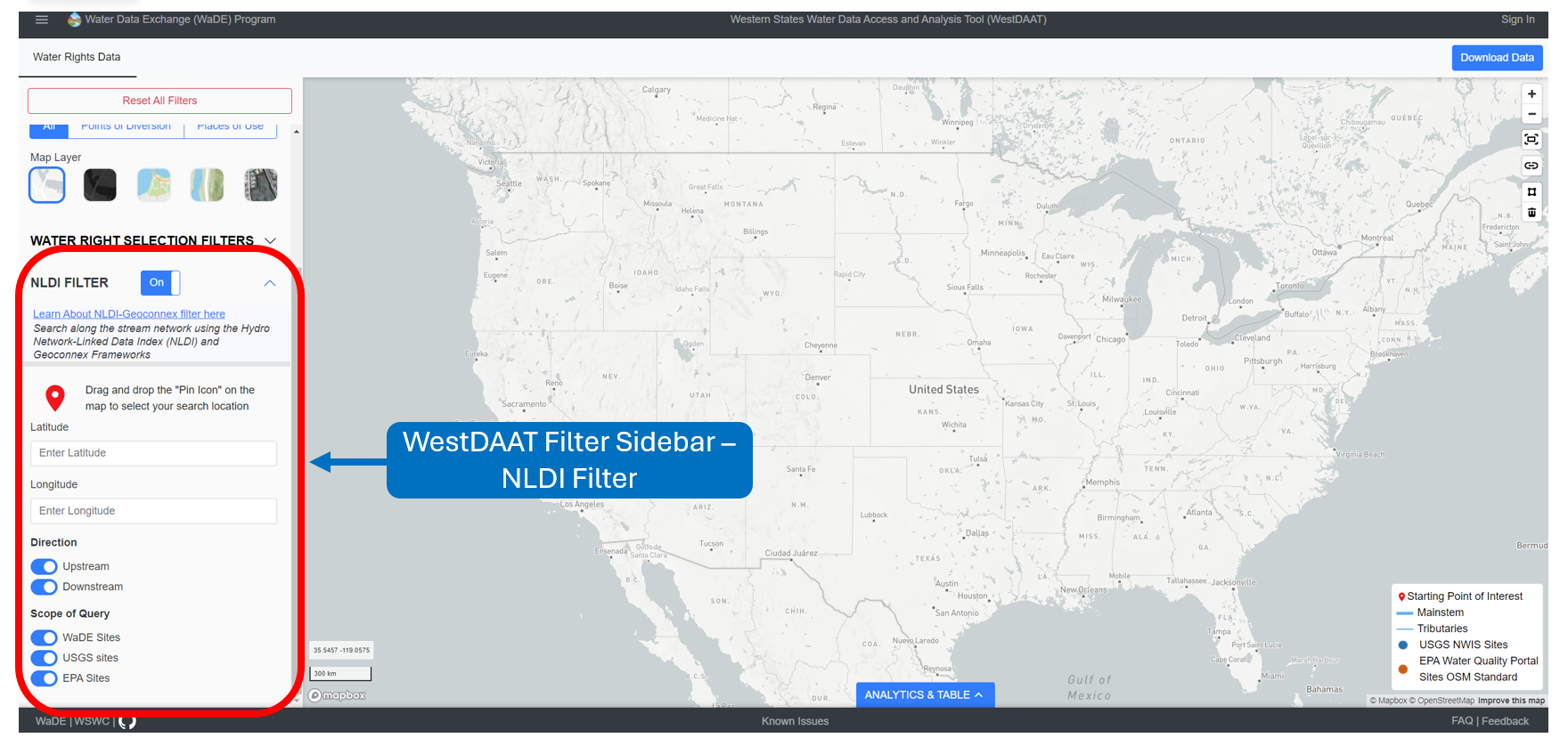
1. NLDI Filter: A toggle button to initiate the NLDI tool. This will expand the NLDI filter tool to its full extent and clear the map of all currently viewed sites water right sites for ease of site / pin location selection. Relevant sites to the NLDI tool call will regenerate to the selected pin location.
2. Drag and Drop Pin Tool: A drag-and-drop pin that allows a user to generate NLDI results wherever they want on the accompanying map. After doing so, the latitude and longitude text box entries are auto-filled. Uses EPSG: 4326 geographic coordinate system.
3. Latitude: The optional text entry field for latitude values for the NLDI query. Auto-filled with the above Drag and Drop Pin tool. Uses EPSG: 4326 geographic coordinate system.
4. Longitude: The optional text entry field for longitude values for the NLDI query. Auto-filled with the above Drag and Drop Pin tool. Uses EPSG: 4326 geographic coordinate system.
5. Direction: Toggle button(s) that indicate the direction of the river index query. Can be toggled on or off.
6. Scope of Query: Toggle button(s) to indicate the scope of site data to query and return. Can be toggled on or off. Includes options from other Geoconnex Framework partners. Options at this time include (1) WaDE water right sites, (2) USGS stream gage sites, and (3) EPA water quality sites.